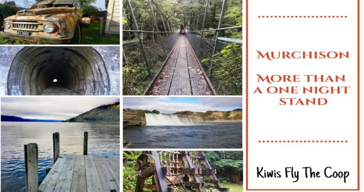
You would be forgiven if you thought that Murchison was just a great place to stopover on your way from point A to B. What else is there to do in Murchison you may well ask?
Where is Murchison?
Murchison is located in the top half of the South Island in the Tasman Region. It only has a population of around 500 permanent residents living there.
A Checkered History
Hampden
Murchison did not come into being until gold was discovered in the area. The town was originally surveyed in 1865, under the name of Hampden.
The grand old ‘The Hampden Hotel’ still holds the original name of the old town (1865-1882). The name was changed so as not to be confused with another South Island town with a similar name.
The hotel has had numerous name changes including Downie’s Hotel, Ross’ Hotel and Mocketts Hotel. This information was kindly supplied by a local resident. Not all research can be sourced by Google search.
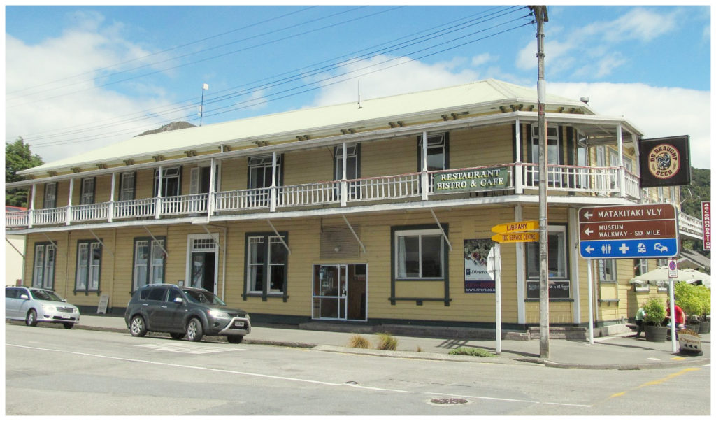
The grand old Hampden Hotel
Suicide Attack
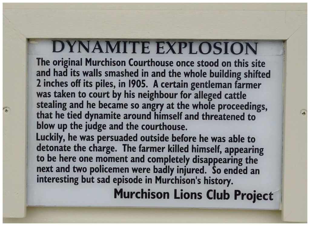
Another interesting fact that I didn’t know is that it is believed that Murchison was the first place in the world to witness a non-military suicide attack. Back in 1905, a very long neighbourly dispute between two farmers resulted in a court case. One of the farmers had sticks of dynamite strapped to his body. He obviously took exception to the outcome of the proceedings. Once ushered out of the courtroom, he detonated the charge when police tried to arrest him. His body was blown to pieces and two policemen were seriously injured.
Travel is knowledge – certainly learnt something about Murchison
Murchison Earthquake
In 1929, Murchison was the epicentre of a massive earthquake. With an estimated magnitude of 7.8, it was felt throughout NZ. Apparently, the rumble was loud enough to be heard in New Plymouth. The noise must have been horrendous along with the violent movement. Seventeen people lost their lives. Most of the deaths were as a result of landslides.
There are displays and information on the earthquake in the quirky little museum in the main township.
Pakawau to Murchison
We packed up, hitched up, checked off the departure list and hit the road in Pakawau, Farewell Spit (see the previous blog). It was a 218km roadie to get to our next destination of Murchison. We had our eyes set on the NZMCA Park (#6317) located in the town centre.
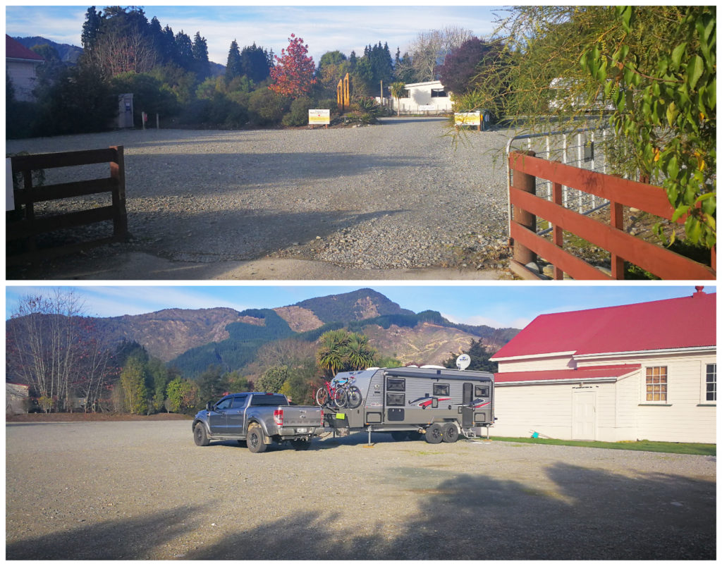
The NZMCA Park, Murchison
It is a large flat, hard stand park which can hold a maximum of 50 vehicles at any one time. There is rubbish facilities on site as well as a very convenient Dump Station and potable water. At only $3 per person, per night, it is a wonderful place to stop.
The icing on the cake (so to speak) is its close proximity to a couple of wonderful pubs, tearooms, convenience stores and a couple of very interesting 2nd hand shops.
I also have it known that we heard from an excellent source, that they do a really mean steak at the Commercial Hotel (even takeaway version!).
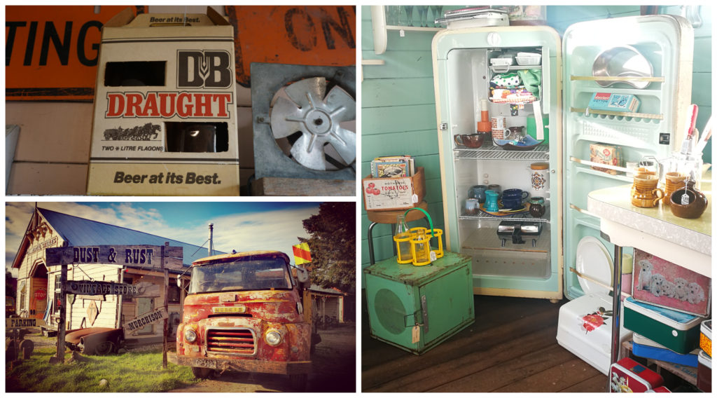
Fossicking in Murchison
Now I don’t know about you, but we love fossicking around Secondhand Shops! Not that we can hoard anything in our ‘home on wheels’ but it is just the pleasure one gets from seeing things that take you back to your upbringing. Those quirky little things that still bring a smile to your face. You never know, you just might see that one little thing that you know that you ‘absolutely just can’t live without’.
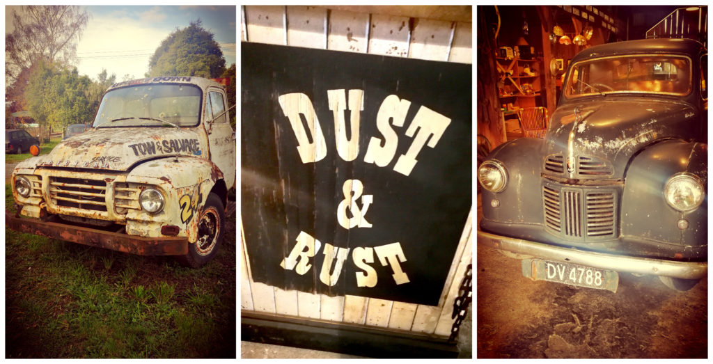
Dust and Rust
Now, this treasure trove is right next door to the NZMCA Park.
Be prepared to get lost for a while as you step back in time
Dust and Rust will capture your interest as soon as you set eyes on it. Although it has only been opened since 2014, the Commercial Stables building is the oldest remaining wooden stables in NZ. Built in the 1890s, it was in a time when horse transportation was the only form of getting from A to B, it is where the horses would be tethered whilst thirsty and tired travellers stopped over to recover at the Commercial Hotel before continuing on their arduous journey.
There’s just something about old relics
It is the perfect setting for a vintage store. As soon as you walk through the doors, you are transported back in time with numerous vintage items for sale. From toys, music, instruments and machinery and much more. It is a retro and antique hunters heaven.
It is worth a look even if you aren’t in the market for vintage items.
Get Lost
Aside from Dust and Rust, you can easily spend more time, wandering around two or three more small odds and sods type shops, secondhand book shops and Op Shops. When this all gets too tiring, you have the opportunity to quench your thirst at either the Commercial or Hampden Hotels or grab an ice cream at the local tea rooms.
The Greater Area of Murchison
We were keen to explore the greater area of Murchison to see what was on offer.
Lyell and the Old Ghost Road
If you travel 34km from Murchison, you will come across the site of the historic gold-rush town of Lyell. There is an easily accessible grassed campsite.
When gold mining faltered around 1900, Lyell died too.
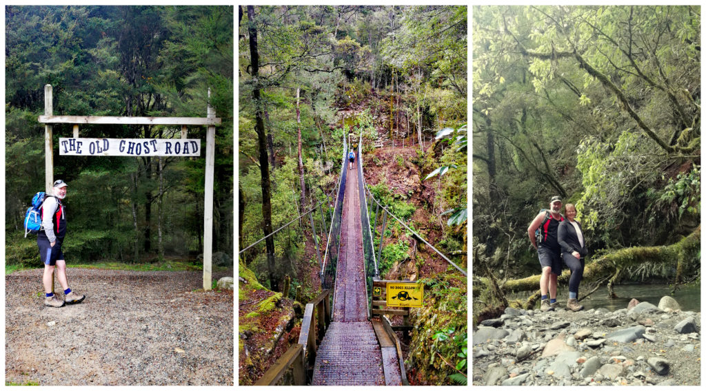
Walking a part of the Old Ghost Road
This is where the Old Ghost Road starts (or finishes). This follows a long-forgotten gold miners’ road which has now been revived as a mountain biking and tramping trail. Starting from Lyell to the Mokihinui river (Seddonville). It covers 85km in total and four ghost towns populate the route.
Needless to say, we didn’t have time or inclination to set out on an 85km hike, so we opted for two of the shorter walks which also start at the camp car park.
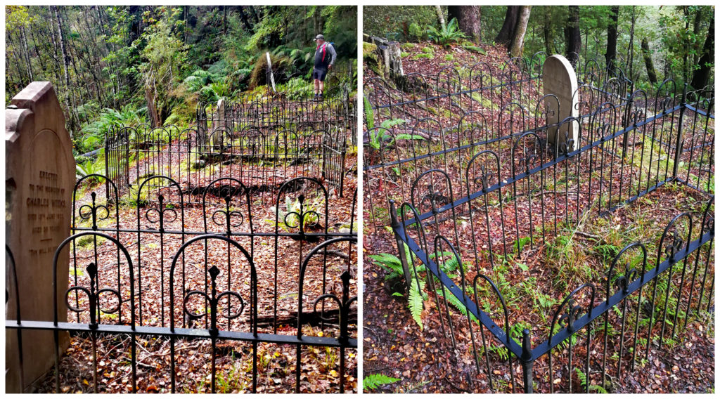
Lyell Cemetery
From the campsite, you immediately walk over a suspension bridge and pass the former Catholic Church site, entering the native forest, following a steep hillside. This leads to one of the picturesque goldfield cemeteries.
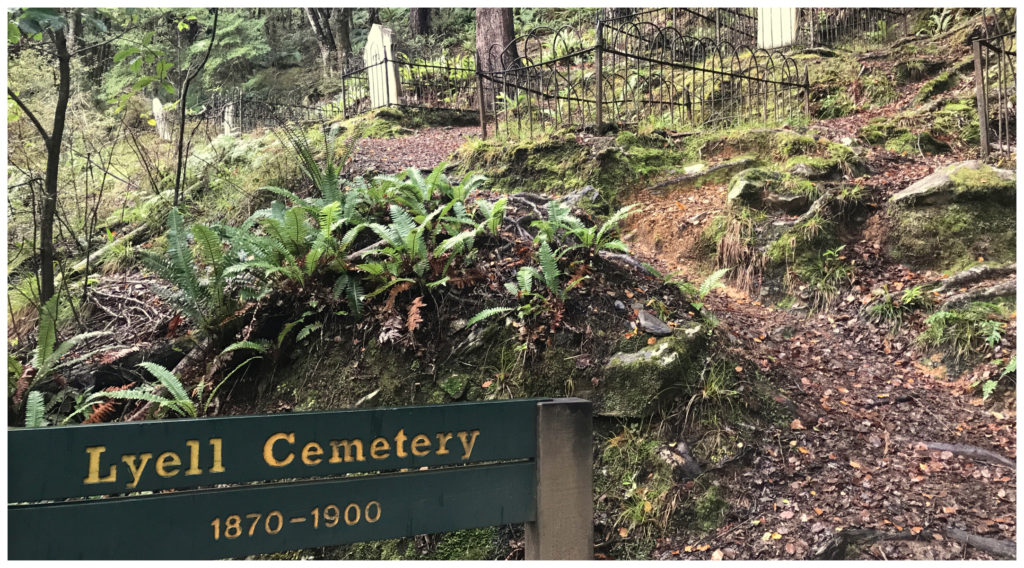
Set on a steep hillside, must have meant a hazardous task for pallbearers taking the deceased to their final resting place!
Mother nature is trying her darndest to claim back this plot of land. There were large trees growing out of the iron-fenced plots. As with most historical cemeteries, the headstones tell the stories of lives cut short and tragic deaths. Between 30-40 people were buried here from 1880 to 1900. For every grave identified by a crumbling headstone, there would be another one lost to oblivion and back into the clutches of nature.
Just another 10 minutes further along the track, we came to Maori Bar (aptly named seem Maori were the first to discover gold in this area). This was the site of the first gold strike in 1862. There is a tunnel which miners drove through solid rock to divert the creek to make the mining a little easier.
Croesus Battery
Continuing on for another couple of kilometres, we crossed the creek at the junction to the Old Ghost Road and continued on to the Croesus Battery.
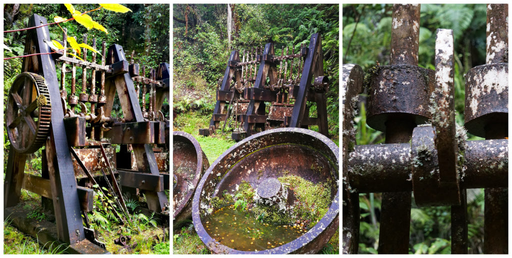
Plenty of relics at the battery site
We came to the lookout point, overlooking the old battery. You can reach the battery via a steep track and steps.
It was at this time that I had to pause and wonder, how did they get all those solid metal pieces of machinery down there! The pounding would have echoed down the valley as the battery continued its relentless task of smashing and crushing quartz using heavy steel balls, hour after hour, day after day.
Reading the signboard, it appeared that all this work was in vain. The gold haul had not been successful and the investment in getting the site set up was not offset by the amount of gold exhumed.
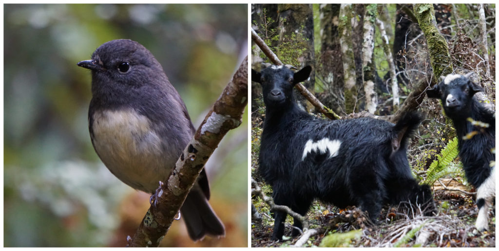
Some of our friends we made along the track
We concluded our walk by returning to the camp via the Old Ghost Road.
Maruia Falls
A drive of 22km along SH65 from Murchison and you will find the powerful Maruia Falls.
It’s not unusual for waterfalls to be created in NZ by the upthrust of rock along a fault line during an earthquake. However, after the 1929 Murchison Earthquake, the Maruia Falls was formed by a massive landslide further up the Maruia Valley. This diverted the river, forcing it to cut a new path over an old river bank.
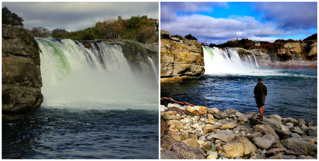
Easily accessible with a 5-minute walk from the carpark
Easy Access
An easy 5-minute walk from the carpark, you will soon hear the roar of the cascading water, as it plummets down the rock face to continue its journey. You will first arrive at the upper lookout platform, then you have the option to wander down further to the waterfall’s base.
We noticed that there were warning signs placed strategically along the path, advising visitors not to climb over the barriers. Wouldn’t you think common sense would prevail, but apparently not. There have been a number of deaths over the years by either jumping off the falls or swimming at the base. The most recent drowning as late as 2017.
Six Mile Walk
Just a short 10km from Murchison is the Six Mile Walk. This is the site of the first hydro-electric power station built in NZ.
The return track takes around 1.5hrs and starts/finishes at the old Six Mile Hydro-Power Station by Six Mile Creek Bridge.
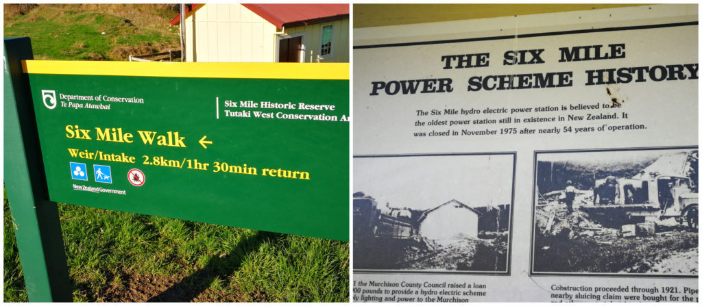
There is history at Six Mile Creek
The hydro scheme opened in 1922 and provided power to Murchison and homesteads in the Six Mile Valley. It operated for 54 years before it was deemed uneconomical and closed in 1975. The power station has been well maintained and we were freely able to wander around inside and out. All the workings are still very much intact and it looks like it could be started up at a moments notice to continue its mission of generating power.
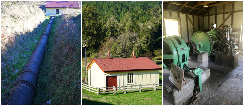
The gravity fed pipeline, the small powerhouse and the all the workings inside
Tracks Less Travelled
At the start of the track, we zigzagged uphill beside the old intake and water storage reservoir. This of course provided enough gravity for the water to drive the station’s turbine. We continued to follow the water race to an old dam which diverted some of the water down to the race.
We eventually made it to some low falls which made for an ideal photo stop. It was a very pretty trail and not one that is used very often by visitors to the area.
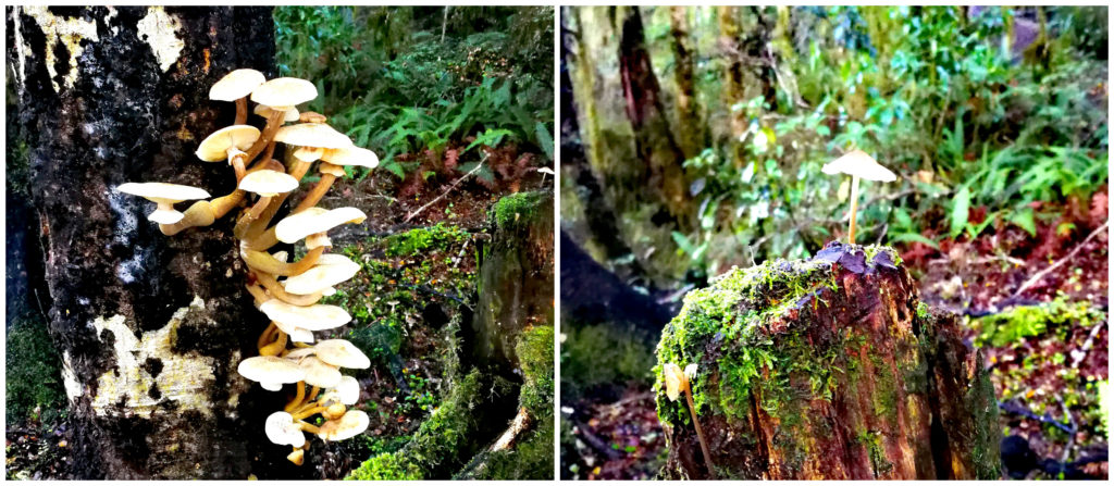
Mushrooms thriving in the moist conditions
We wandered the track for around 1.5hrs. A neighbouring house at the start at the track was the home of a rather friendly black labrador. There was no way she was going to stay at home so she accompanied us the entire way to the falls. She was adorable and kept an eye on us to make sure we were still following her. It was obvious that she walked this track often and knew where to go.
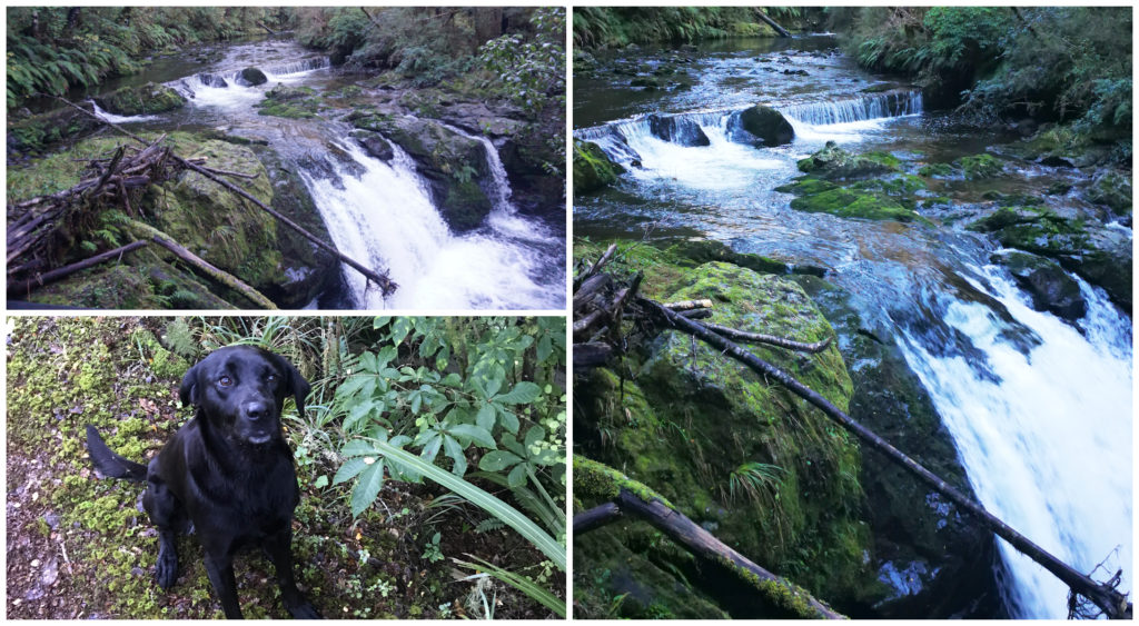
The falls at the end of the track and our random walking companion
Braeburn Walk, Lake Rotoroa
Approximately 32km from Murchison is Lake Rotoroa. Situated within the borders of the Nelson Lakes National Park, it is surrounded by beech forests and is a whopping 145 metres deep.
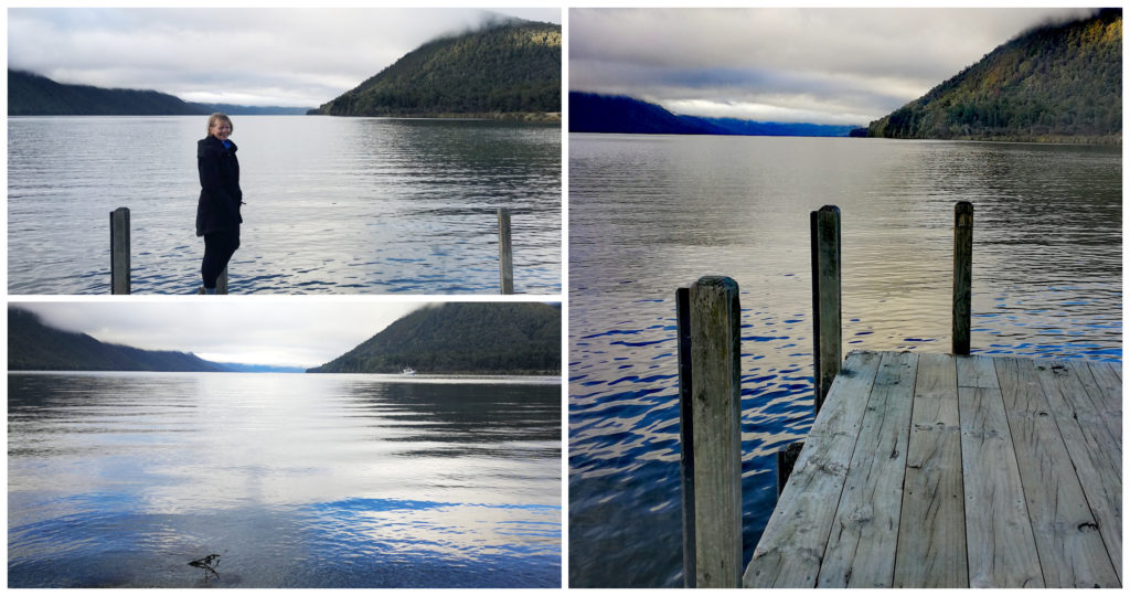
Lake Rotoroa is a remote and very beautiful deep water lake surrounded in forests and mountains
There are a number of hikes you can take depending on how much time you have to spend in the area. As we had a lot of ground to cover in the Murchison area, we choose to check out the Braeburn Walk.
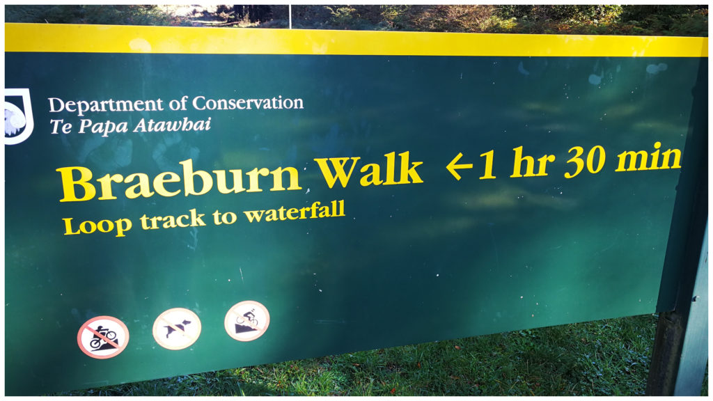
A 1.5 hour loop track leads along a wide and well-formed track through some amazing beech forests, draped in moss. This rich green growth wrapped itself around every tree and stump making it look like a carpet layer had come in and fitted it out.
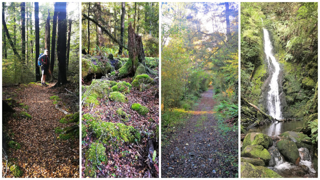
Carpet of moss, the old roadway and cascading waterfalls
Moss Layden
We followed the track as it climbed up the hill as it zigzags up to a picturesque mossy waterfall.
The track initially followed the remains of a road constructed in the 1950s which was dug out while they investigated the area for a location for a hydro-electric installation.
This walk leads along a wide and well-graded track through a diverse remnant of beech and tall podocarp forest rich in bird life.
Kawatiri Railway and Pikomanu Tunnel
We are always suckers for any history surrounding old railways. We are often captivated by the story around the building of railway lines, bridges and tunnels. Each line tells a story of either success or failure.
We were keen to investigate the Kawatiri Railway line and Pikomanu tunnel which is located at the Kawatiri Junction (SH6 and 63), 35km from Murchison. There is a car park where the historic Kawatiri Station platform still remains.
The platform now hosts a number of information panels and photos that provided us details on the history of the rail line and the Pikomanu settlement that used to exist nearby. The work camp at Pikomanu housed over 300 labourers, tradesmen and other support staff.
History
Kawatiri was one of 25 stations on the Nelson section and was pretty much the end of the line. The line did extend for a couple of kilometres further on but was never continued any further than Gowan Bridge and Owen. It was one of the shortest-lived stations as was only in operation for just over 5 years (1920-1926).
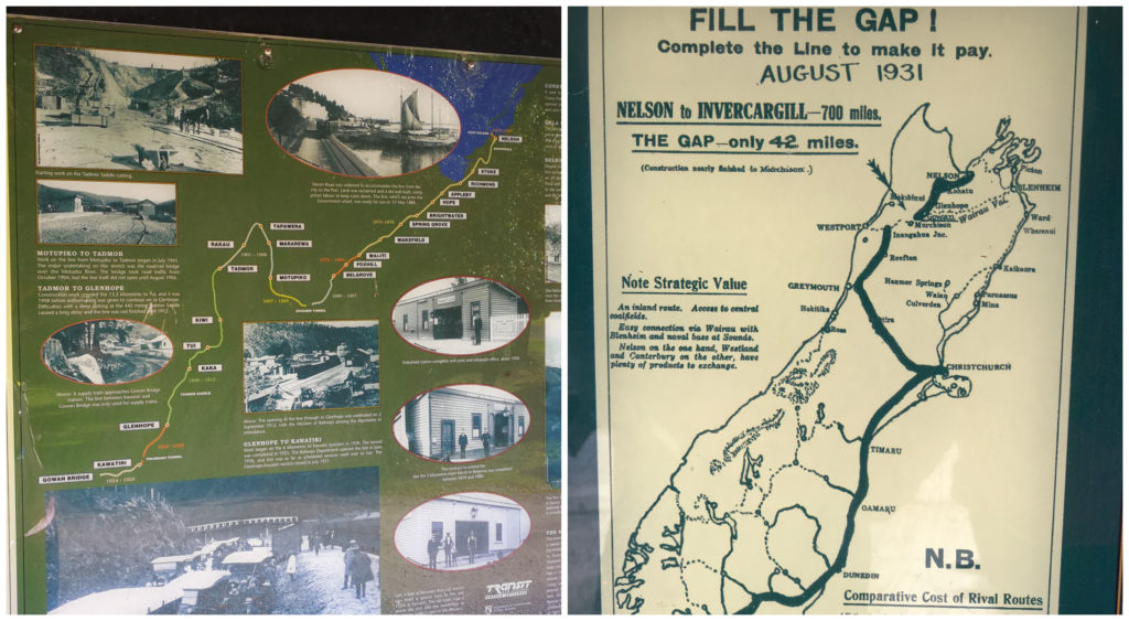
If only they had bridged the gap!! Just imagine travelling by train from Nelson to Invercargill!
From what we have read, the whole line was a bit of a flop. Right from the start, it only saw two passenger trains a week. This was soon discontinued and goods trains were the only trains arriving at Kawatiri and the odd Public Works construction trains.
Due to the economic depression, there was a halt to all construction work and brought a sudden end to all regular traffic through the station. Several months later, the plug was pulled in 1931 and the line was closed in 1955.
The Walk
There is a short 20-minute loop walkway that crosses the Hope River over a pedestrian footbridge that uses the old rail bridge piers. This leads into the Pikomanu Tunnel. A torch is not needed but watch where you step as you may need to tiptoe around some of the puddles that form throughout the tunnel.
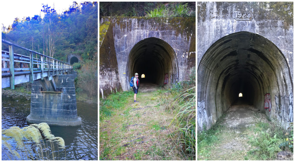
Walking the Pikomanu Tunnel
The walkway then climbs a staircase and loops back over the top of the tunnel, through beech forest and along the Hope River bed. Keep a lookout for a hollow that was carved into the rock face on your left. This was used as an explosives store by tunnel construction workers.
This trail will bring you out at the starting point by the footbridge.
Skyline Walkway Summit
We had been reading about the views at the top of the Skyline Walkway. Located on the outskirts of Murchison (2 km out of town) at the Matakitaki Bridge Scenic Reserve, it is a 1.5hr return hike to the top of the lookout.
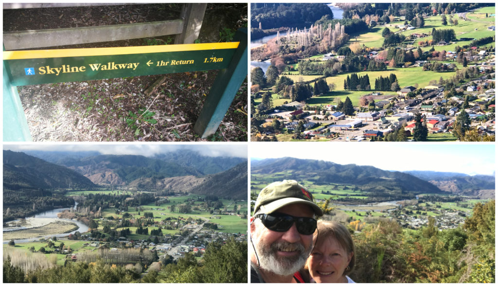
Taking in the views (after catching my breath!!), overlooking the town of Murchison
Don’t be fooled by the mention of the track grade of ‘easy’. Yes, it is a well-formed track but believe me – it is ALL uphill! I’m sure I nearly puffed up a lung on the way up! In saying that though, it is well worth the exertion once you get to the top. There are a couple of peaks so don’t think you’ve finished when you make it to the first. Carry along the track a bit further and you will get to the actual summit.
You are rewarded with views across Murchison township, the Matakitaki, Buller and Matiri rivers. The biggest river is the Buller which eventually flows into the Buller Gorge.
Summary
Give Murchison a chance to wow you as much as it wowed us. If you have the time, stay and play for a while. After all, it is known as the ‘whitewater capital’ of the country – if you are into that kinda thing (especially in summer!). There are literally rivers everywhere (the Gowan, Mangles, Matiri, Glenroy, Matakitaki, Maruia and the mighty Buller). If rafting isn’t quite your ‘thing’ then there’s jet boating, gold panning and fishing.
You can also walk the longest swing bridge in the country. We passed on this as we didn’t want to pay the $20 for the privilege and we’ve walked quite a few large and long swing bridges.
Click on the link below to view the video on some of our highlights in Murchison.
Fabulous Blog. We are heading South in January, very excited reading about your adventures and we can’t wait to start making our own memories. Thanks so much for sharing.
Veronica
Hey Veronica, so pleased to hear that you will soon be hitting the road too. There is just so much to see in our beautiful country and we never take our lifestyle for granted. You must be counting the days until you can ‘fly the coop’ too. Thanks for the feedback and it’s a pleasure to share our experiences and we hope it can help or inspire others to grab life and live it to the full. All the best with your upcoming plans. Might meet you on the road one day. Linda
My family has been in Murchison for generations and it is often seen as only a ‘tea and pee’ stop! The walks are gorgeous , I have done a few of these while I lived there and now I am in Aus I still make sure to visit Lake rotoiti whenever I am home, it’s such a hidden gem! Thankyou for this well written article
Thanks Jolene for taking the time to give us feedback. It sounds like there is a lot of family history for you in Murchison and I can understand how it could keep drawing you back. You are lucky to have a connection to such a wonderful town. Long may that relationship continue for you. Linda
Wow thanks for sharing your interesting blog My dad was a five year old at Murchison school when the earthquake happened so it’s on the bucket list to go to hopefully next year on our bus travels He later with his parents moved to New Plymouth where we are based
.
Oh goodness, you do certainly have special history in Murchison! It will be extra special for you to spend some time in the town and know your Dad has walked some of those streets as a small boy. You must be really looking forward to hitting the road next year. Might meet you on the tarmac some time. Linda
Great article! We’ve been through Murchison twice and haven’t seen a quarter of our narrative (note to self: must see more next time through)
Just a tiny nitpick the word Māori never has an “s” added to it for plural or possessive forms.
thanks for the feedback…..and for the critique – I didn’t realise that, will amend – thank you!!!👍👍
Great article, as you say we have a beautiful country, do you find your van big enough for permanent living. Regards Gary
Hey Gary, thanks for your feedback, we really appreciate it. We chose the layout for the van carefully so that we can have a degree of separation between living, bathroom and bedroom. It just gives us a sense of space, quietness (when I get up early and boil the billy!) and separation in an argument (just kidding!!!). It’s still at a size where we can get to those out of the way places (especially with the off-road capacity). It’s a fine line trying to get what you want, what is important and practicality. It’s also a personal choice – what we love won’t suit everyone. Hope that answers your question. Linda
Wow! What a surprise area Murchinson proved to be. At the beginning I was struck by how isolated this area is. Yes it has a tiny permanent population. Yet, it is an area rich in history and stunning natural beauty. Thanks for sharing:)
These little towns have the biggest surprises for sure.
There’s so much to do around Murchison, especially for the hiker! I would be more attracted to the ‘five minutes’ walk from the carpark’ variety – or at least, no more than half an hour, which is my limit at the moment after a knee replacement. You certainly found out plenty about the rich history of the area.
Next time you visit Murchison you must go on the guided natural flames walk.
Thanks Olly, we hear that it is a great attraction and very popular.
I lived in Murchison for about 18 months and grew to love the town and area. It has an atmosphere and heart not found in many places today. A great place to stop and “take five”. Dont forget to stop off at the famous Murchison Tearooms for a cuppa.
Thanks for your feedback Glenice, and agree 100%. They are doing a great job at keeping that atmosphere alive. We did visit the tearooms but went straight to the ice cream cabinet and chowed down on a mint and choc chip ice cream…..as you do!!!! Linda
Interesting read
We were on our way from Westport to Nelson so had a brief stop in Murchison. The town was busy with travellers and had a good “feel” with most buildings in good condition. We visited the second hand shop…and the one across the road. We didn’t get inside the Museum but I gather its good and has a lot of history re the earthquake. Good to read your blog and get a better impression of the town.
We paid the $20 for the swing bridge as it was a novelty. I led the way and my wife followed. I could hear lots of swearing behind me 🙂
Haha, I understand how your wife came out with some colourful language. I swear a lot as I’m sure Scotty purposely makes those bridges swing more than necessary. I’m glad my blog helped you to get a better understanding of a brilliant wee town. Linda